GIS Solutions for Health
Introduction
The tremendous potential of GIS to benefit the health care industry is just now beginning to be realized. Both public and private sectors are developing innovative ways to harness the data integration and spatial visualization power of GIS. The types of companies and organizations adopting GIS span the health care spectrum--from public health departments and public health policy and research organizations to hospitals, medical centers, and health insurance organizations.
Identifying Health Trends
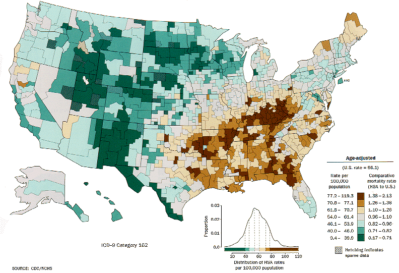
The demographic data, such as home address, workplace, cancer type, and even data collected from wearable health tech of all patients entered into the system. Data is then georeferenced and mapped. Healthcare professionals can visualize the locations of patients and determine if there are clusters of specific types of cancer associated with similar working conditions or residential areas.
WWith the number of chronic diseases such as cancer, diabetes, and cardiovascular disease rising rapidly, GIS may provide a method in which healthcare professionals can systematically address where certain diseases are more likely to or already have become prevalent and begin proactively implementing preventative strategies or staffing healthcare professionals skilled in specific medical specialties.
Tracking the Spread of Infectious Disease
The role of GIS systems should not be limited simply to tracking occurrences of diseases though. One of its most powerful aspects is its ability to use geography and other inputs to identify where diseases are most likely to spread next. Data such as this can be essential to on-the-ground personnel working to save lives because it enables them to prepare in advance for a disease and can severely limit the impact.
Utilizing Personal Tech
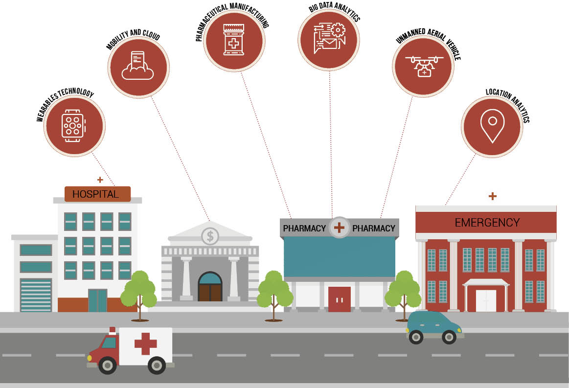
The collection of large quantities of accurate personal data is expected to reveal a great deal about personalized healthcare, but it can also greatly impact broad regional treatment plans. Personal healthcare technologies represent a powerful tool for information input into GIS due to their ability to inform statistical studies. It has the potential to uncover long-term geographic trends in the health of certain demographics of people or of individuals living within certain regions of the United States.
Improving Services
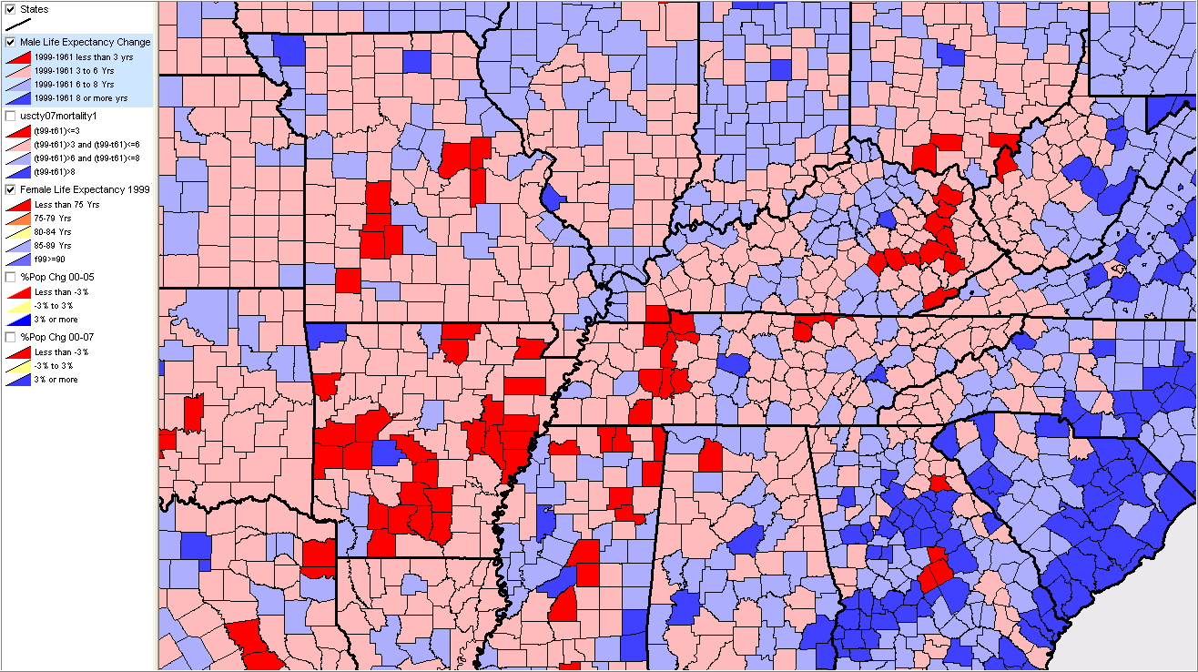
Finally, the use of GIS technology can enable community leaders and developers to work more closely with hospitals to take larger steps in addressing national healthcare needs. The system can help identify which neighborhoods are in greater need of specific health services such as more rehab centers or senior care facilities. Analysis of patient demographic data can help answer these questions
Applications
Market development
Understand current assets in relation to the population being served.
Opioid crisis management
Visualize opioid overdose locations and connect people with resources
Opioid epidemic management
Map current services and programs, and identify areas that need resources.
Population health Management
Create strategies with GIS to improve systems that affect the health of the community.
Disease surveillance
Collect and analyze data from disparate sources and visualize the effectiveness of interventions.
Marketing
Use limited resources more effectively to reach current patients as well as target areas of interest.
serve the homeless populations
Mapping out homeless shelters to offering govt. aid services in those areas.
Public health preparedness
Prepareness needs Proper Planning & Responding to the challenges with GIS.
Mobile data collection
Enabling mobile data collection for health and human services event..
Use Cases: Geospatial Data At Work
Infectious Disease Detection and Prevention
Part of the reason to use geospatial data for tracking infectious disease is that environmental factors are known to play a role in health outcomes. By applying GIS technology to this issue, researchers can address disparities in outcomes for various populations. For example, there may be a link between a neighborhood’s walkability and incidence of depression in that location. Certain communities might also have higher levels of obesity, which could be related to availability of fresh foods. Mapping health outcomes would reveal these relationships and help researchers identify and protect sensitive populations.
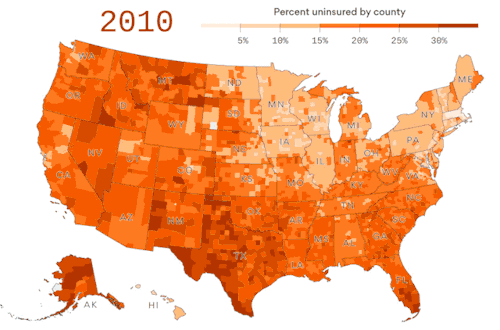
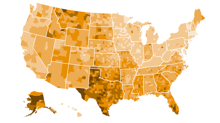
Health Insurance
Health insurance companies are continually striving to better understand healthcare costs. By applying location data, they’re able to explore such questions as whether patients who live close to polluted areas — bus depots, chemical plants, airports — trend toward requiring increased healthcare premiums

Hospital Marketing
Hospitals and other medical centers can use geospatial data to better understand the community they serve and anticipate needs in their service area. They can also identify patterns to determine with greater precision where to invest their marketing efforts, answer questions about where their patients are coming from, how far they travel to obtain services and whether their home community is healthy.